Cycling Palestine gave me a real sense of connection to the political geography of the land. A connection I had not experienced on previous trips to the country. The man-made tools of occupation or ‘protection’ – barriers, checkpoints, road blocks – stood in marked contrast to the earthy and fertile land. The shining asphalt of the Israeli engineered roads were a world away from the unpaved dirt tracks that led to many of the small hillside villages. All were physical representations of the politics that shape how people can or cannot move from place to place around the land.
Palestine is marked by the ‘green line’: the designated border agreed after the 1947-49 war. In the 1990’s, the Oslo Accords laid out the deal brokered between the Palestinian Authority and Israel, providing Palestinians with the theoretical right to self government. The West Bank was divided into three administrative divisions: Area A, to be exclusively administered by the Palestinian Authority, Area B to be jointly administered by Palestine and Israel and Area C to be administered by Israel (Area C comprises 61% of Palestine and is home to many Israeli settlements) . Areas A and B were chosen to contain Palestinian population centres. Area C surrounds them and, in Area C, Israel retained full control over security, civil affairs, planning, building, infrastructure and development. Our cycle tour took us from Israel, into Area C and in and out of Areas A and B. The majority of the miles were ridden on land that is designated as Area C. This is important because it shaped the quality of the rodes we were able to ride on…
On the first day we followed a route from Tel Aviv airport (located on the Mediterranean just 5 m above sea level) to Jericho (nestled 280m below sea level looking across to the Jordan Valley and the Dead Sea). Our version of the Coast-to-Coast! The route swept up and down fantastically smooth and wide roads that connected the city to the Palestinian hills and the towns beyond. We headed towards Taybeh, a Christian village that is home to Palestine’s most famous brewery. This was one of the high points of the ride: literally because it sits at 950m above sea level and symbolically because it marked the beginning of The Descent of the tour. The 14 mile ride down to Jericho was world class. Long sweeping roads, little traffic, perfect tarmac and brake pads frying in the heat. 1100m of pure cycling buzz in one hit. Yes, this nervous descender has been converted (sort of – lets just say I didn’t get any strava cups for my time!). Where was the Giro? And what an amazing climb it would be – perhaps best left for another trip during cooler months.


We passed across the Green Line at the start of the day, just 12 or so miles into the route. Remarkable that the distance was so small and, all the more so, since the only evidence that we had crossed the ‘border’ was the faint dotted line showing on our Garmin maps. It was quite a distance further along the road before we saw evidence of checkpoints – a reminder of the subtle ways in which borders can be pushed and territories extended.
We marvelled at the quality of the roads. Much of our route was through Area C. The incursion of Israeli occupation was evident throughout the area. Settlements were dotted across the hills and valleys, encroaching on ancient Palestinian land. The shining roads evidence of the infrastructure in place to provide easy access to the settlers and support development. We cycled on smooth wide tarmac, with enough room for us to ride safely out of the reach of passing traffic – a world away from Devon lanes. Even on busier highways there was always room (well, apart from in Jerusalem. And Nablus). But, when we had time to take a breath and glance up from the trance like pedalling of the uphill slogs, we would spot the trunk roads that led to settlements, the guard post in the distance and signs showing a Wolf which seemed to be the settlers mark. Often there were barriers on the roads, ready to ‘secure’ settlements and cut off access if needed.
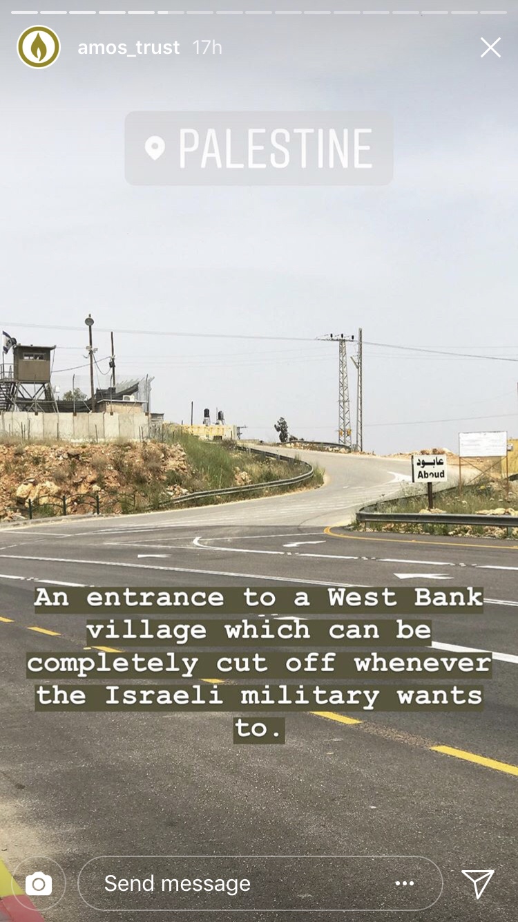
Sometimes the roads that branched off the main roads were unkempt, worn down or downright dust tracks. These were always roads to Palestinian villages. Many cut in half by the criss crossing pattern of the settlements and the roads that connect them. We had heard tales before of villages being cut in half by road developments that the villagers were unable to drive on. This type of activity just contributes to the gradual wearing down of Palestinians and its hard to see it as anything other than a deliberate act designed to gradually ‘encourage’/force them to leave the land. Riding through on a bike gave me a real sense of just how much the Palestinian landscape has been shaped and re-shaped by the Israeli government.
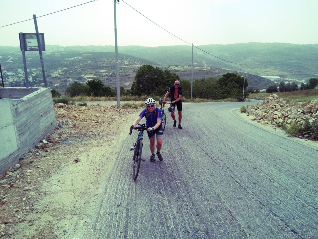
James observed this week that that the steepest and sharpest climbs were often on the poorly maintained roads leading to Palestinian villages. The longer but more joyous gradual climbs reserved for the highway roads dominated by Israeli cars. This doesn’t feel like a coincidence. Gradients as steep as 25% were not uncommon and, on one particularly hot and rough climb, the gradiant stayed at 20%+ for over 900m of narrow, half finished and busy road. One by one we came off our bikes, the steep terrain too dangerous for us to hold. Jacs made it the furthest but still bailed near the top as it became impossible to keep her wheels in contact with the tarmac or weave safely from side to side in the manner that was necessary to make the climb achievable. With cleats and slick road tyres one wrong turn could have been fatal. Although the slow tottering walk, pushing bikes as we tried not to fall on our tiny cleats, was probably harder in the end!
Although we rode mainly in Area C, whenever we approached the towns and villages in Areas A and B we were met with more watchtowers and the imposing red signs that denoted Palestinian presence. DANGER TO ISRAELI CITIZENS. Is it any wonder that people have so much fear of the other when signs like these are part of their day to day reality?

We stayed in the larger towns that marked the end points of our daily journeys: to the east, the north and the south. Jericho was a vibrant town, it felt somewhat isolated and maintained a sunny, outward feel. Jenin, in the North, is built on fertile land. The hills and fields are greener and we approached as the villagers were harvesting the cucumber crop. The city has seen many troubled times and the refugee camp buildings were littered with bullet holes, a stark reminder of the ongoing vulnerability of life for those living in them. In Bethlehem, Aida Camp was a familiar friend. Narrow streets, UNWRA schools where the only windows were narrow slits (to avoid bullet fire hitting the children in lessons) and stories of tear gas not letting us forget that this was a refugee camp. Warm welcomes from the children on the streets and the team at Al Rowwad reminding us that even in the midst of despair humanity can prevail.
Our third ride, from Jenin to Taybeh, took us from the North of the country southwards towards Taybeh and then on to Bethlehem by bus. The landscape was the most stunning I have seen in Palestine and the 68 mile remains my favourite ride to date. Ever.
Gentle rolling hills gave way to long sweeping climbs and sudden sharp ascents. Our first destination was the historic village of San Sebastia, located midway between Jenin and the city of Nablus. We truly bonded ‘to the land’ when google maps failed us and our route took us up a dirt track and over a mountain path. Whilst mapping routes is possible using the modern apps available to riders, google maps hasn’t yet fully imaged the Occupied Territories so it was often impossible to see whether smaller roads were rideable or not. A dusty road became a track, which became a gravel track and then a hike. A hike with a bike. Ali, the wonderful driver of our support van, valiently followed us until the gradient became too much for his truck. He turned back, choosing to take the long road diversion (political geography at work again) to the village where we were heading. A bemused farmer, tending the olive groves on his small tractor, waved as we hiked past, our bikes slung over our shoulders or pushed out in front. Forty five minutes or so later the village emerged in the distance – Ali and the van stood with a group of local farmers, ready to greet us and wave us off on the rest of our journey!


We rode on to San Sebastia. A coffee stop in the village square, with accompanying recorder-playing from an old man and his grandson, and a chance to survey the damage to our cleats. San Sebastia is associated with the Tomb of John the Baptist and is also the site of the best preserved Roman Ruins in Palestine. A huge amphitheatre lies beneath the village and some of its columns are visible in the fields below. Archaelogical excavation has not been possible – archaelogical endeavours a victim of occupation.


The ride from San Sebastia to Nablus was less eventful, but took in genuinely undulating roads that wound through the valleys between the hilltops. Nablus was steep, busy and hot. A beautiful city reputed to serve the best Kanafah cake in the world, we stopped only to refuel with falafel from a roadside cafe and then moved quickly on, keen to put some distance between ourselves and the hectic city traffic. The journey south to Taybeh took in some of the most prolonged and beautiful climbs I think I will ever ride. In the mid afternoon light, we pedalled upwards, silently working our way to the top of roads that seemed to last for miles. Peaceful and focused. We had been warned that the final climb up to Taybeh was hard. I loved it. High on adrenalin I found my rhythm. I even saw some breakaways and catch up attempts nearer the top. When we reached the turn-off to the village we were jolted out of our cycling high by the presence, once again, of that RED SIGN and the checkpoint guard towers. We cycled past, aiming for the famous brewery that is at the heart of the town. In true British style we arrived too late. It was closed. We had to settle for a bottle in the local hotel, before jumping in the van for the ride to Bethlehem.


The next day we headed south and into the Hebron Hills. We were only able to skirt the city of Hebron itself – our bikes would not be able to fit through the narrow turnstiles that mark the checkpoints into the Old City. Most of us had visited Hebron before and were still haunted by memories of walking down the near empty souks of the Old City, where settlers have moved into building above Palestinian homes in a direct act of harassment and where cordons cut off section off streets and pavements from one another – a large path for the setttlers, a narrow strip for the Palestinians. Hebron is a depressing reminder of the brutality of the occupation and as we rode out of the suburbs towards the hills we noticed the increased presence of military patrols and cars along the road. Gav and Jacs spotted a mysterious military vehicle parked on the road, it’s driver filming us as we rode past. A short time later they were both stopped by a police patrol car and questioned about our activities and destination. I’ve already written about the situation for the villagers in Al Tawani and the ride there summarised, in a nutshell, the profound experience of cycling through a military occupation in one of the most beautiful lands you can imagine.
So for the cycling fans out there. Here’s the TP summary of our two big rides.
And if you’re interested to see what the political geography looks like on a map (source Middle East Eye map included in a 2018 article maps from the website (www.palestineportal.org)
Those roads. Those hills. That descent. Doesn’t it make you want to ride here?


